Saturday, August 14, 2021

Biking Historic Virginia - part 2

If you read the previous post here in the blog, then you know that my family and I spent about a week in eastern Virginia, soaking up history in a part of the country that's just steeped in it. Well, our vacation is done, and we're back home in Akron - but now I have some time to write about how I spent my last day in VA.

In doing some reading about bike routes and trails in the area around where we were staying, I learned about the Colonial Parkway, which is operated by the National Park Service. The parkway connects the three main historic villages of colonial Virginia - Jamestown, Williamsburg, and Yorktown - all located on the peninsula between the James and York rivers. These villages form what is often known as the "Historic Triangle." The parkway provides a beautiful, natural landscape and scenes, and somehow manages to avoid views of modern development. The roadway is wide and paved in concrete which has a surface of what appears to be river pebbles - which is supposed to make it recall (somewhat) the look of a colonial-era road. There are very few intersections (it usually passes over or under crossing roads) - and instead has "exits" to access the few other roads it actually intersects. For cyclists, the parkway's features, and lack of big trucks, make it an excellent route - though I would highly recommend a steel-framed bike and with tires of at least 32mm (or more) in width, because that "pebbly" surface can really generate some "buzz." Luckily for me, the Sequoia perfectly fit the bill. 

The parkway is about 23 miles long from end to end. But for me to ride the whole thing, I needed to turn it into a loop that started and ended at our "home base." I mapped it out and ended up with a ride of almost exactly 50 miles.

My start/end point is at that big red dot, to the north-west of Williamsburg. To ride the parkway, I'd have to ride south to the settlement of Jamestown (which incidentally is also where the Capitol Trail starts, which I'd written about in the previous post) - then east along the James River. Then the parkway heads north to the village of Colonial Williamsburg, and then turns east again to the York river, and eventually to the village of Yorktown. At that point, I'd have to return along the parkway back to Williamsburg, and then take the regular roads back to our home base. One caveat for bicyclists riding the parkway is that in Williamsburg, the road enters a pretty long tunnel that passes completely underneath the restored historic village. Bicyclists are prohibited from riding in the tunnel. It is necessary for cyclists to "exit" the parkway just before the tunnel starts, ride on the surface streets through Colonial Williamsburg, then get back on the parkway. This is hardly an inconvenience because it lets you see the village by bike (which is nice). The National Park Service website offers a suggested route for that little detour - but on the whole, it isn't hard to figure out for anyone with a map.

I left "home" at 7:00 am, and arrived in Jamestown at about 7:30. Even at that early hour, the temperature was already in the 80s, with ungodly humidity, so within minutes I was already getting soaked in sweat, and dripping. Here, near the start of the parkway, I had a nice view of a marsh and a creek that flows into the James River.


Passing through these wooded areas at this hour, there were these lovely shafts of sunlight streaming through the trees. But the fact that the sunlight is glowing like that is also an indicator of how high the humidity was. Remember - that's water vapor glowing there in the sunlight. These pictures also give an idea of the parkway itself, which as I've said, is nice and wide - but also lacks any lines or lane markings. You can kind of see that pebbly surface I mentioned, which does generate a high-frequency "buzz." Most of the time my tires and frame managed to soak it up pretty well. Traffic was overall pretty light - especially early in the morning.

I mentioned above that the parkway has minimal intersections, and either passes over or under crossing roads. Most of the bridges one passes under are built of red brick, like these shown here - giving them an attractive colonial-era look. I should also mention that the parkway is very well maintained.

I spotted this flock of wild turkeys along the way. You know - unlike the bloated, genetically engineered domestic varieties bred for Thanksgiving dinners, wild turkeys deserve some respect. They are pretty ugly birds - but they "own" it. They are also clever - and they can defend themselves. It's a good idea to give them a little space. Though the frequently repeated notion that Benjamin Franklin had actually wanted the turkey to be the "national bird" is actually a myth, he did in fact have some thoughts on the subject - expressed in a letter to his daughter. An excerpt: “For my own part I wish the Bald Eagle had not been chosen the Representative of our Country. He is a bird of bad moral character. He does not get his living honestly. You may have seen him perched on some dead tree near the river, where, too lazy to fish for himself, he watches the labour of the Fishing Hawk; and when that diligent bird has at length taken a fish, and is bearing it to his nest for the support of his mate and young ones, the Bald Eagle pursues him and takes it from him. . . The Turkey is in comparison a much more respectable bird, and withal a true original Native of America… He is besides, though a little vain & silly, a bird of courage, and would not hesitate to attack a Grenadier of the British Guards who should presume to invade his farm yard with a red Coat on.”

About 25 miles into my ride, I emerged from the woods to my first glimpse of the York River.

Okay - so this was an unexpected sight. I came around a bend to see the flashing lights of a sheriff's car and a couple of tow trucks - looked out into the river, and saw this car about half submerged in the river. I have no idea how it got out there. I can't imagine a car getting that deep into the river on its own power unless it was really flying when it hit the water. Did it go in at some other point in the river and get pulled further out by the current? Did the driver go out there while the tide was low - then get trapped as the tide came in? (I'm not familiar enough with the area to know if the river is affected by the tides to that extent - but I assume there must be some tidal effects). By the time I'd be on my return ride, they'd have it out.

Seeing this bridge in the distance told me I was getting close to Yorktown. That's the Coleman Memorial - US Route 17 bridge from Yorktown to Gloucester Point. It's a moveable "swing bridge" that can open up to allow navy ships access to the Naval Weapons Station on the York River. At this point, I must have been about 5 miles from the end of the parkway.

Speaking of that Naval Weapons Station - here it is. 


The Parkway ends in Yorktown at the historic battlefield. If folks don't remember from their American History classes, Yorktown was the site of the final siege in the Revolutionary War - where Lord Cornwallis surrendered to Washington in October 1781, thereby ending the war and guaranteeing our independence.

Upon reaching the end of the parkway, I decided to ride around the village of Yorktown to see some of the sights before heading back. It's a lovely little town with some interesting stories.

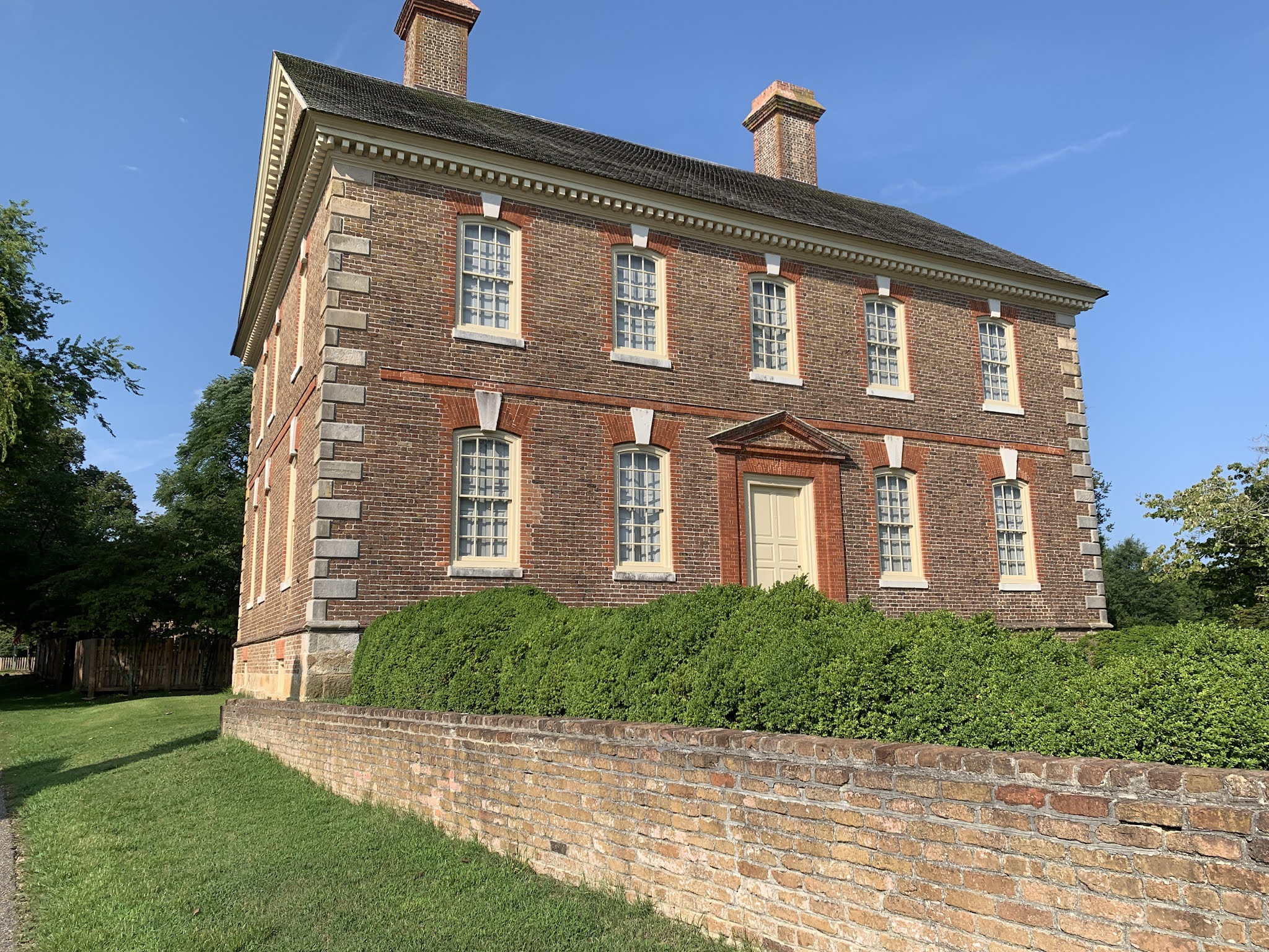
This was the home of Thomas Nelson - signer of the Declaration of Independence, representative for Virginia in the Continental Congress, and a brigadier general in the Virginia Militia - and one of the commanders of American troops in the battle of Yorktown. Later he would be elected to follow Thomas Jefferson as Governor of Virginia. Some interesting history on Nelson, and his home: British troops captured Yorktown in August of 1781, took over the local homes to board their soldiers, and dug in for battle. Being one of the largest and grandest houses in the village, Lord Cornwallis selected Nelson's home as his headquarters. When the American and French forces arrived to battle the British, the American troops, led by Nelson, opened fire on Nelson's own house. Legend has it that Nelson offered a prize of 5 guineas to the first soldier to hit his house. Now that's what we call commitment to a cause.

Signs of the battle are still evident all around the Nelson house - with holes and divots all over the outside bricks. Here, you can see a cannonball still lodged in the wall. Too cool. I was also told that the house was used as a hospital during the Civil War, and local legend says the house is haunted by the soldiers who died in it.

Anyhow - Yorktown was a huge tactical mistake for Cornwallis. French ships totally blockaded the York River, bottling up the British Navy, and cutting them off from supplies and reinforcements by sea - while American and French soldiers moved in by land to surround the British forces - then bombarded the hell out of them. The siege lasted a couple of weeks, during which time the British were weakened and ran out of ammunition, food, and men. By October 17th, Cornwallis was asking for terms of surrender.


Shortly after news of the victory reached the Capitol, Congress commissioned the construction of this monument. It wouldn't actually be built until 100 years later - which could be seen as evidence that Congress has always moved at a snail's pace. Fun fact: that figure of Lady Liberty on the top of the monument is NOT the original statue from the 1880s. The original figure was struck by lightning in the 1940s, which literally blew her head off. A new figure was created and put in place in the 1950s (apparently with a lightning rod running through it, and a pretty extensive grounding apparatus installed). 

Anyhow - after seeing the sights in Yorktown, I went back to the parkway and the ride back to the home base. By the time I was heading back, the temperature was in the mid 90s. I should mention that there are literally no places along the parkway to stop for water or other refreshments - especially on that long stretch (approximately 15 miles) between Yorktown and Williamsburg. So having plenty of water is key. I had an extra bottle in my saddlebag - but by the time I got back to Williamsburg, that was just about gone too. The "Market Square" area in Williamsburg has a number of places to stop for food and drinks - so that was like a welcome oasis.

Well - a 50 mile tour of the historic peninsula was a great way to finish up my vacation in Virginia. The next morning, we faced a 9-hour drive back to Ohio. I'll just wrap this up by mentioning that Virginia is a beautiful area for cycling - with lots of resources and amenities for riders - lots to see and do - and the people I encountered were genuinely friendly. Seriously - I got friendly waves and "hellos" from people everywhere I went. So overall it was a great place to take a bike and explore. 

That's all for now - Till next time . . .

Thursday, August 12, 2021

Biking Historic Virginia - part 1

I had mentioned in my last post that the family and I would soon be taking a vacation trip - and that's exactly what we did. We made a drive from Ohio south to Virginia, where we would be spending about a week in the Williamsburg area - in the eastern part of VA, near the Chesapeake Bay. Well, by the time this gets posted, we'll actually be wrapping it up and on the way back home. But since we were driving, it was a simple matter to bring a bike - which as far as I'm concerned, is the best way to explore someplace new (or in this case, someplace very old).

There is a lot of history in this part of the country - which has always been a point of interest for me. I mean - I'm an English teacher, but for me, History was also a possible path. Seriously - how many people do you know who read Alexis de Tocqueville's Democracy in America at 17 - and not as a required reading assignment? I'd seen enough references to it in other books that I figured I should check it out. You know - for a little "light reading."

Anyhow . . . this part of Virginia is full of destinations for anyone interested in history. Colonial period, and Revolutionary War history and lots of Civil War history too. Everywhere you go, there are old battlefields, historic homes, monuments, gravesites, museums, and more. We had plenty of activities planned out as a family, but I also made sure to leave some time for riding during our stay.

On my first day out on my bike, I got out early while everyone else was still asleep to do some exploring without wandering too far from our home base. I planned out a ride to Colonial Williamsburg, which was about a 20 - 25 minute ride away from "home." Most readers are probably at least somewhat familiar with Colonial Williamsburg, but in case anyone needs the info - it's a fully restored "living history" village, where people dress in 18th century clothes, and give demonstrations on all aspects of colonial life. Williamsburg had been the capitol of the Virginia colony until 1780, when the capitol moved to Richmond. After the move, Williamsburg basically became just a sleepy little southern town until the 1930s, when a foundation was created to restore it to its 18th century appearance. 

Getting to the restored village at 7:30 am on a Sunday morning meant that I was seeing it before the other tourists started arriving, and before anything was open. There were lots of workmen and maintenance people all over the village - cutting grass, trimming shrubs, making repairs - and then by 9:00 am, they all clear out, and the folks in period costumes take over the scene.

One of the major parts of the restoration of Williamsburg was to completely rebuild the Governor's mansion, restoring it to its former glory. Again - I was there before opening - so the gates made a decent backdrop for a bike shot. And yes, I did also get to see the place during normal hours with the family, tour the inside, and explore the gardens and grounds. It's impressive.

Another bike pic - just outside a paddock where historical re-enactors would be doing demonstrations later  in the day. As folks can see, I brought the Sequoia, which has become a favorite riding mount since its restoration last year.

I explored the village some more, riding up and down the various streets, checking out the houses and shops. One thing I found interesting is that Colonial Williamsburg is also a residential community. While some of the houses and shops are open for tours and demonstrations - some of the houses are actually private residences. The foundation apparently owns all the buildings, but they lease some of them out for people to actually live in - primarily some of the village's re-enactors. So it wouldn't be so unusual to see, for example, the village blacksmith emerge from one of these houses in the morning, dressed in period costume, and head off to work.

Just outside the restored village of Williamsburg sits the College of William & Mary, which I learned is the second oldest college in the U.S. (Founded in 1693 - only Harvard is older).

My first stop on the campus was the square where the original and oldest buildings are located. But honestly - the whole campus is gorgeous. Almost all the buildings keep a similar style architecturally, with the same style and color of brickwork. Seriously - even their football stadium is designed to blend in with the historical buildings (at least in as much as a stadium can).

After riding loops around the restored village and the lovely college campus, I headed "home" to get ready for a day of touring and activities with the family. I think my ride was about an hour and a half - and maybe 15 (mostly) relaxing miles.

My next excursion would be much longer. I did some checking about bike routes and trails in the area, and found that we were only about 10 miles away from one end of the Capitol Trail - which runs from the historic Jamestown Settlement to the city of Richmond. It's a little over 50 miles from end-to-end. The trail mostly follows a route beside some of the rural highways, though it is fully separated from them - and at least one section of the trail is on a former railroad line. The trail is paved, well marked, and has mile markers (which can be handy). And again - though many readers may already know it - Jamestown was the first permanent English settlement in North America - and it includes the story of Pocahontas, Capt. John Smith, and all of that - though most versions of that story are highly romanticized and likely inaccurate. All I'm sayin' is that the Disney version is way off. So was the one I learned as a kid, for that matter.

Aaannyhow. . .

I drove down to Jamestown to start the ride. There was a large parking lot at the trailhead, and parking was free. Though riding the full length of the trail all the way to Richmond would have been great, I did not feel up to a ride that would end up being over 100 miles out and back. I determined I'd ride a respectable stretch of it, and turn back.

Shadow selfie. Much of the eastern stretch of the trail is flanked on one or both sides by trees - mostly pines, so there were many long stretches of shade, which was nice, since it was going to be a hot day. It was nearly 80 when I started out, and that was at 7:30 am! It would be well into the 90s by mid-day.

The eastern half of the trail is mostly flat (I was told by a fellow rider I met along the way that it gets a little hillier closer to Richmond). The longest and steepest hill I had to climb was the bridge over the Chickahominy River, which that same rider told me is known as "Mount Chickahominy" by the local riders. At least the path is very wide, and there is a very substantial barrier between it and the car traffic.

The view from the top of the bridge. Did I mention that I do not enjoy heights?

Okay - so there are historical markers or signs all along the Capitol Trail. I didn't stop to read every one of them (there were a lot) - but I did read this one, and it seriously bothered me. In case you can't read the text, here's the short and dirty version: This Paspahegh Indian chief resisted the intrusion of the Jamestown settlers, and their stealing of his tribe's lands - so the English settlers killed his family, and wiped out his tribe, then eventually they killed him in a "skirmish" near Jamestown in 1611. Jeezus.

Upon returning from my ride on the Capitol Trail, I wanted to extend my ride a bit by heading down to James Island. I found that by following the road just a short distance from the trailhead, there is a nice quiet road, called the "Island Road" or the "Island Drive" that takes you on a lovely loop around the island.

Most of James island is either woods, or tidal marshes. The "Loop" lets you see plenty of both. The tide was out, so the middle of this marsh was lots of muddy bottom and tide pools.

Some of the loop around the island is made up of boardwalks like this one - that extend out over the marshes. 

I did map out the day's ride - which ended up at right around 40 miles total. A respectable ride for the day.

That's all I'll cover for now. I'd manage to get out for one more "epic" ride before heading home, and I'll cover that in the next post. 

Till then . . .

Monday, August 9, 2021

An Early Morning Ride

I haven't had a lot to post about lately - this summer has had me off the bike quite a bit for various medical things, minor surgeries, and other procedures - Nothing too serious or alarming - but it has meant that I haven't been able to ride as much as I might otherwise. For a guy who rarely gets sick, and almost never goes to the doctor, it seems like I had to have a lot done all in one summer.

Anyhow - I'm doing better - and I did finally manage to get out for a nice ride, early in the morning, just a bit after sunrise. We had some mist in the lower lying areas, especially down in the valley - and I needed to stop a few times for some pictures.

At one point, on a narrow and twisty stretch of road that is mostly closed to traffic (or at least, car traffic) I came down a short hill, around a bend - and damn near ran head-on into this buck standing in the road. I swerved, and he bolted - but he didn't go far before stopping to look back. That was a bit of a scare - but a good one.

Had to get at least one bike picture in here - it is a bike blog after all. 

Passing by a marsh - known as "the beaver marsh" - though truthfully speaking, I've never actually seen a beaver there. I know they do live in the marsh, as one can see where they've chewed some of the trees, and there is definitely a beaver hutch out there in the marsh if you know where to look. But an actual living beaver? Strangely, I've yet to see one. But the sun coming up, just behind the trees, cast an awfully pretty glow over the scene. Those flashes of purple you can see out there - that almost look like purple flames rising out of the water - are actually a non-native, invasive species known as "purple loosestrife" that the national park service would like to be able to control. It's apparently harmful to the native species - but it does look pretty.


There are cornfields like this scattered all over the valley, along both banks of the Cuyahoga River. Here you can see some fog just starting to burn off as the sun is coming up. Passing by the fields at this hour, you can really smell the corn. It smells sweet, which shouldn't be a surprise. They've been harvesting and selling the corn at the little farm market for the last couple of weeks, and I think the corn so far this season has been the sweetest I can remember. We've had a lot of rain this summer - especially earlier on - but more recently, we've been getting a lot more sun. Evenings have been cool, and the days have been warm and sunny - and something tells me that those are probably the perfect conditions for the best sweet corn.

Well - that's all I've got for now. We'll be heading out for a family vacation very soon - and I'm taking a bike, so there will be a report coming up. 

Until then - happy riding.